Introduction
Flows
WTGA describes the direction/path of streamflows in each watershed, listing monitoring stations in order from headwaters to outlet, including a flow rating (where available), flow volume in cubic feet per second (CFS), the depth of flow in feet and inches, the water temperature and specific conductance (where this information is available). WTGA logs a snapshot of the stream flows through the state’s rivers and tributaries weekly, as per USGS Waterwatch current streamflow monitoring stations.
- Rivers, and creeks flowing much above normal or high (in the top 10% of flow volume recorded for that system) are shown in boldface;
- flows that have breached action stage appear in red,
- flows in flood stage appear in boldface red type.
Flow volume can change rapidly during snowmelt and rain events. All readings are posted as they appear as of our monthly update.
During melting and rain events, check your local upstream station flow levels at the USGS WaterWatch Current Streamflow site or sign up for high flow alerts. Streamflow data is subject to review as sensors at the monitoring stations do malfunction from time to time. See USGS Provisional Data Statement at the end of this report for more information.
Groundwater Monitor
USGS Groundwater Watch, periodic measurements of depth to water at selected test well sites in each watershed. WTGA shows the trend in groundwater level from one periodic measurement to the next, we check for new USGS measurements and update here weekly.
Impaired Water Bodies (IWB) EPA 303d list
The EPA requires all states to update a draft list of impaired water bodies (the 303d list) every two years; providing a period for public comments, and presenting the draft list to the EPA. The final 303d list is published as approved (or partially approved) by the EPA, roughly every two years.
Impaired water bodies are defined as those with contaminants measured above threshold levels, as set by the EPA Clean Water Act, or where the desired use is impaired. The latest Draft List for Georgia is available on this site.
This report tallies the total impaired water bodies in each watershed area. The list includes Georgia lakes, creeks, rivers and reservoirs that require management limiting release of contaminants and nutrients, a Total Maximum Daily Load (TMDL) plan. The TMDL plan is a type of Clean Water Plan, established by a collaboration of municipal, industrial and environmental groups in an overlay zoning district.
Hazardous Algae Blooms (HABs) Beach Alerts
Hazardous algae blooms are reported here as they are reported to the Georgia public complaints portal and confirmed by Georgia EPD. EPD contacts the water body local management and conducts testing for algal toxin levels if necessary. According to Georgia EPD Media spokesperson, there have not been instances of algal toxins in excess of recreational water use limits.
- New confirmed HABs will be listed with the diamond bullet ♦ by water body, date and time of the report, in the applicable watershed, with location information (accuracy of our location description is limited by the accuracy of the location tag in the EPD report).
- HABs previously reported that remain in active status are shown with a dash bullet.
Archived reports for the water body are mentioned in small print.
Contact parks management for the current information on local conditions before heading out and consider using an on-site rapid test for microcystin.
Spills
Georgia EPD 24 hour Emergency Operations Center 1-800-241-4113
National Response Center (NRC) at 1-800-424-8802
24-hour emergency line staffed by US Coast Guard for oil spills on water.
As per EPA Oil Discharge Reporting Requirements, the reportable amount of spilled oil product is any amount that leaves a visible sheen on the surface or sludge at the bottom of the water body. Such spills are to be reported immediately (within 15 minutes). Spills from a vessel into navigable waterways are to be reported to the NRC in compliance with the Discharge of Oil regulation and Prevention of Oil Pollution regulation of the EPA.
From Georgia EPD Emergency Operations Centre, “oil” includes but is not limited to: gasoline, crude oil, fuel oil, diesel oil, lubricating oil, sludge, oil refuse, oil mixed with wastes, and any other petroleum-related product. Accidental discharges of oil during maintenance of one’s own personal vehicle or farm machinery shall be exempt from the reporting requirement.
Note that all spills should be cleaned up, whether or not they are reportable.
WTGA lists oil, diesel fuel and other hazardous materials spills as recorded in the Complaint Tracking System Public Portal. Complaints of spills, along with reports/notes from the assigned inspector or responding agent are listed in the watershed area where they occur.
Reporting from the latest records uploaded to the Georgia EPD Public Complaints portal. Oil, diesel, gas, and chemical spill reports are posted following incident response, with notes on remediation actions taken. Various spill types are searched categorically each week and posted by watersheds in which they are confirmed to have occurred.
- New spills over 40 gallons are listed weekly in the watershed in which they occur with the diamond bullet ♦, including location of the spill, the contaminant spilled (if known), the quantity (if known) and the resource affected (if known) surface water, groundwater, sewer, etc, and any amounts of contaminant material recovered at the site.
- Spills reported previously and current within 30 days of the report are reported with a dash bullet.
- Spills over 100 gal, very toxic chemical spills and spills that impact water, the highlighted spills are flagged and tracked with state and/or EPA authorities for more information. See the CrimeBox for details on violations and charges under the Clean Water Act.
Sources:
WaterToday Georgia aggregates information and data from the Georgia Department of Natural Resources, Environmental Protection Division, Georgia Health, EPA Region 4; United States Geological Survey WaterWatch Current Streamflow, USGS Groundwater Watch, National Weather Service, National Oceanic and Atmospheric Administration by watershed area. The accuracy of the information contained in our reports is dependent on these sources. Provisional data statements apply, and confirm data with local authorities before taking action.
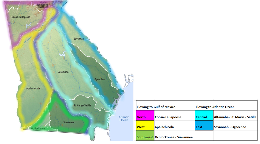
Georgia’s landscape sends rainfall in two directions from the height of land, also known as the drainage divide: southwest to the Gulf of Mexico, or southeast to the Atlantic Ocean.
Find your location in one of the five sections of our report.
Gulf of Mexico Flows

1 Gulf North
1a Tennessee River Watershed
The Tennessee River collects rainfall and runoff for the Ohio River system, which joins the Mississippi and empties out into the Gulf of Mexico. While no part of the Tennessee River itself passes through Georgia, there are tributary creeks originating in north Georgia that cross the state line and join up with Tennessee waters.
- Lookout Creek drains an area of 149 sq miles of Dade County. The flow is monitored near New England is currently unavailable.
- Chattanooga Creek drains an area of 6 sq miles of Walker County. The flow is monitored at Flintstone: 63.94% above mean, 32.0 cfs and 3.35 ft deep as of 07/12/22
- West Chickamauga Creek drains an area of 148 sq miles in Catoosa County. The flow near Lakeview: 51.52% above mean, 90.1 cfs and 1.24 ft deep as of 07/12/22
- South Chickamauga Creek drains an area of 169 sq miles in Catoosa County. The flow near Ringgold: 86.42% above mean, 85.6 cfs and 4.14ft deep as of 07/12/22
Groundwater Monitor
Walker County Groundwater station ID#0001 water level is trending downward, depth to water measured at 12.05 ft below surface as of July 10th, 2022. (updated here Jul 12, 2022)
Impaired Water Body (IWB) EPA 303d List (167)
- 167 water bodies or sections of water bodies, including rivers, creeks, streams, lakes and reservoirs not meeting desired use or having measured contaminant above threshold levels are listed on Georgia’s IWB 303d list for 2020. See this site for the detailed list under the Gulf North Tab, for Tennessee Watershed.
Hazardous Algae Blooms (HABs) Beach Alerts (Coming soon)
Spills (0 new)
- Spill reports searched for the period July 4- 10 yield no new results
1b Coosa River Watershed
The Coosa River is a collection of several tributary rivers gathered from northwest Georgia. At the beginning of this system, the Conasauga River and Coosawattee Rivers join up to form the Oostanaula River. The Oostanaula in turn joins flow with Etowah River system to form the Coosa River. The Coosa runs west into Alabama where it merges with the Tallapoosa River across the state line in Alabama, forming the Alabama River, eventually reaching the Gulf of Mexico.
(Confusion alert** Watch for another river by the same name (Chattooga) in northeast Georgia! These two are not the same.)
- Conasauga River drains an area of 8.24 sq miles in Murray County. The flow at Tilton is normal, 41.40% above mean, 313 cfs and 3.02ft deep, as of 07/12/22
- Mill Creek drains an area of 40 sq miles in Whitfield County. The flow at Dalton is above normal, 83.75% above the mean, 34.8 cfs and 4.36 ft deep, as of 07/12/22
- Coahulla Creek drains an area of 176 sq miles in Whitfield County. The flow near Dalton is 30.62% above mean, 95.2 cfs and 7.87 ft deep, as of 07/12/22
- Coosawattee River drains an area of 831 sq miles in Gordon and Murray Counties. The flow at Pine Chapel is above normal 202.54% above the mean, 2580 cfs and 9.62 ft deep as of 07/12/22
- Talking Rock Creek drains an area of 119 sq miles. The flow near Hinton is normal, 69.56% above mean at 82.2 cfs, 1.32 ft deep as of 07/12/22
- Holly Creek drains an area of 1602 sq miles in Gordon County. The flow near Chatsworth is normal, 17.61% above mean at 15.9 cfs and 1.08 ft deep. The water temp is 27.4°C, as of 07/12/22
- Fausett Creek drains an area of 9.99 sq miles in Gilmer County. The flow near Talking Rock is normal, 102.71% above the mean, 12.5 cfs and 1.61 ft deep as of 07/12/22
- Oostanaula River drains an area of 2115 sq miles in Gordon and Floyd Counties. The flow at Resaca is above normal, 149.68% above the mean, 3240 cfs and 6.62 ft deep, as of 07/12/22
- Etowah River drains an area of 1634 sq miles in Dawson, Bartow and Cherokee Counties.
- The flow at GA 136 near Landrum is 121.15% above mean at 213 cfs and 2.49 ft deep (flood stage is 14 ft), 23.3°and 24µS/cm;
- at GA9 near Dawsonville is 101.29% above mean at 270 cfs and 4.76 ft deep (flood stage is 13 ft) 23.0°and 25 µS/cm ;
- at Kelly Bridge near Matt is 103.14% above mean at 460 cfs and 2.06 ft deep (flood stage is 19 ft); downstream of I-575 at Canton in Cherokee County is 104.52% above mean at 824 cfs ad 4.01 ft deep (flood stage is 17 ft);
- at Canton is normal, 91.36% above mean at 923 cfs and 2.86 ft deep (flood stage is 16 ft) 25 C;
- at Allatoona Dam above Cartersville in Bartow County is below normal, 24.20% above mean at 359 cfs and 1.27 ft deep (flood at 9ft) 19.9°C;
- at Allatoona Dam 690.10 ft deep; at GA61 near Cartersville is 27.65% above mean at 551 cfs and 5.24 ft deep (flood stage is 18 ft);
- near Kingston is much below normal, 55.45% above mean at 1070 cfs and 4.40 ft deep (floods at 20 ft) as of 07/12/22
· Two Run Creek
- drains an area of 33.1 sq miles in Bartow County. The flow near Kingston is normal, 22.32% above the mean, 14.3 cfs and 1.21 ft deep. (update 07/12/22)
· Oothcalooga River
- drains an area of 62.6 sq miles in Gordon County. The flow at GA 53 spur near Calhoun is 40.26% above mean, and 44.6 cfs and 7.19 ft deep. (update 07/12/22)
- Coosa River drains an area of 4040 sq miles in Floyd County. The flow near Rome is normal, 88.30% above mean, 4270 cfs and 12.43 ft deep (flood stage is 24 ft). The water temp is 25.7°C. (update 07/12/22)
- Chattooga River (of the northwest) drains an area of 4040 sq miles of northwest Georgia. The flow at Summerville is normal, 84.32% above mean at 142 cfs and 2.53 ft deep (flood stage is 14 ft). (update 07/12/22)
Groundwater Monitor
- Gordon County Groundwater station ID#1601 water level is trending downwards, depth to water measured at 23.66 ft below surface as of July 11th, 2022. (updated here Jul 12, 2022)
Impaired Water Body (IWB) EPA 303d List (408)
- 408 water bodies or sections of water bodies, including rivers, creeks, streams, lakes and reservoirs not meeting desired use or having measured contaminant above threshold levels are listed on Georgia’s IWB 303d list for 2020. See this site for the detailed list under the Gulf North Tab, for Coosa Watershed.
Hazardous Algae Blooms (HABs) Beach Alerts (Coming soon)
Spills (0 new)
- Spill reports searched for the period July 4- 10 yield no new results
1c Tallapoosa River Watershed
The Tallapoosa River originates in northwest Georgia, draining an area of Paulding and Haralson counties before crossing the state line and joining the Coosa River, forming the Alabama River.
- Tallapoosa River drains an area of 272 sq miles of Haralson County. The flow at US78 near Tallapoosa is 134.89% above mean at 192 cfs and 2.02 ft deep as of 07/12/22
- Little Tallapoosa drains an area of 245 sq miles of Carroll County. The flow at GA100 near Bowden is 102.72% above mean at 164 cfs 3.52 ft deep; at Carrollton is above normal, 100.20% above mean at 97.2 cfs and 2.68 ft deep as of 07/12/22
- Cedar Creek drains an area of 65.3 sq miles of Polk County. The flow at Cedar Town is below normal, 60.14% above mean at 50.1 cfs and 0.77ft deep as of 07/12/22
- Snake Creek drains an area of 35.5 sq miles of Carroll County. The flow near Whitesburg is below normal, 40.41% above mean at 14.5 cfs and 1.83 ft deep as of 07/12/22
- Snake Creek Reservoir drains an area of 34 sq miles in Carroll County. The flow is 92.61% above mean at 17.8 cfs and 3.41 ft deep. The water temp is 26.9°C as of 07/12/22
- Dog River drains an area of 66 sq miles of Douglas County. The flow at GA 5 near Fairplay 119.41% above mean at 44.9 cfs and 3.55 ft deep. The water temp is 24.7°C. 07/12/22
Impaired Water Body (IWB) EPA 303d List (54)
- 54 water bodies or sections of water bodies, including rivers, creeks, streams, lakes and reservoirs not meeting desired use or having measured contaminant above threshold levels are listed on Georgia’s IWB 303d list for 2020. See this site for the detailed list under the Gulf North Tab, for Tallapoosa River Watershed.
Hazardous Algae Blooms (HABs) Beach Alerts (Coming soon)
Spills (0 new)
- Spill reports searched for the period July 4- 10 yield no new results

2 Gulf West
2a Chattahoochee River Watershed
The Chattahoochee headwaters form up near Helen, in northeast Georgia in the Appalachian Mountains. From Union County, the Chattahoochee flowing southwest, through the capital and then south, forming the state border with Alabama, terminating in Lake Seminole.
- Chattahoochee River drains an area of 8210 sq miles from the northeast to the southwest. The flow
- At Helen is normal, 75.04% above mean at 76.5 cfs and 0.76 ft deep, 21.3°C.;
- at Leaf flow is normal, 68.71% above mean at 283 cfs and 1.98 ft deep;
- at GA100 at Cornelia is normal, 84.37% above mean at 492 cfs and 1.04 ft deep;
- near Fairburn is normal, 81.86% above mean at 2760 cfs and 2.15 ft deep all as of 07/12/22
- Powder Springs Creek drains an area of 23 sq miles of Cobb County. The flow near Powder Springs is 92.56% above mean at 9.33 cfs and 1.59 ft deep as of 07/12/22
- Noses Creek drains an area of 44.5 sq miles of Cobb County. The flow at Powder Road is 11.13% above mean at 11.7 cfs and 2.09 ft deep as of 07/12/22
- Sweetwater Creek drains an area of 13.5 sq miles of Cobb County. The flow at Powder Springs is 35.41% above mean at 113 cfs and 1.44 ft deep as of 07/12/22
- Nickajack Creek drains an area of 31 sq miles in Cobb County. The flow near Mableton is 25.44% above mean at 14.2 cfs and 1.61 ft deep as of 07/12/22
- Utoy Creek drains an area of 33 sq miles in Fulton County. The flow is unrated, 61.65% above mean at 32.6 cfs and 3.15 ft deep. The water temp is 25.2°C as of 07/12/22
- Nancy Creek drains an area of 26.6 sq miles in County. The flow at Atlanta is 24.89% above mean at 13.0 cfs and 0.66 ft deep. The water temp is 25.7°C as of 07/12/22
Groundwater Monitor
- Cobb County Groundwater station ID#2901 water level is trending upwards, depth to water measured at 5.37 ft below surface as of June 9th, 2022. (updated here Jul 12, 2022)
Impaired Water Body (IWB) EPA 303d List (403)
- 403 water bodies or sections of water bodies, including rivers, creeks, streams, lakes and reservoirs not meeting desired use or having measured contaminant above threshold levels are listed on Georgia’s IWB 303d list for 2020. See this site for the detailed list under the Gulf West Tab, for Chattahoochee River Watershed.
Hazardous Algae Blooms (HABs) Beach Alerts (Coming soon)
Spills (1 new)
♦ July 3, 2022 a release of 14,200 gallons of sewage into Sugar Creek at 3100 block of Cottonwood Dr. in Atlanta (Dekalb County) (#100639), the release was caused by a grease blockage in a sewer main. Incident response notes that the blockage was cleared and the main returned to service. No fish kill noted in this report, the follow up assigned to Watershed Protection Branch. Complaint file closed July 6, 2022.
- June 29, Global Warehouse LLC reports a spill of 100+ gallons of diesel fuel at Moreland in Coweta County. Georgia DOT sent a remedial contractor to deal with the clean up. No further action recommended by GA EDT. (Complaint #100603, file closed July 1.)
- June 29, refrigeration tank damaged during transport caused approximately 50 gallons diesel to spill, some part of which entered a storm drain and retention pond. Granular sorbent was applied to the ground spill, Clean Harbours has taken charge of remediation of the water body. (Complaint #100599 closed July 1)
2b Flint River Watershed
The Flint River originates south of Atlanta and gathers run-off from 7570 sq miles of Georgia as it traverses the course north to south, flowing west through Alabama to empty in the Gulf of Mexico.
- Flint River drains an area of 7570 sq miles down the west side of the state. The flow near Griffin in Spalding County is normal, 58.45% above mean at 201 cfs and 3.89 ft deep as of 07/12/22
- below Big Branch, Pike County flow is 32.85% above mean at 527 cfs and 6.12 ft deep as of 07/12/22
- at Thomaston, Upson County, flow is normal, 96.89% above mean at 674 cfs and 3.69 ft deep as of 07/12/22
- near Carsonville in Upson County, flow is normal, 43.17% above mean, 965 cfs and 2.86 ft deep as of 07/12/22
- at GA 26 near Montezuma, Macon County, the flow is normal, 77.95% above mean at 2010 cfs and 3.35 ft deep as of 07/12/22
- at GA 32 near Oakfield in Worth County the flow is above normal, 67.99% above mean at 2870 cfs and 4.73 ft deep as of 07/12/22
- at Albany, Dougherty County, the flow is above normal 105.62% above mean at 5520 cfs and 5.57 ft deep as of 07/12/22
- at Newton in Baker County, the flow is normal, 68.62% above mean at 3870 cfs and 6.30 ft deep as of 07/12/22
- at Riverview Plantation near Hopeful in Mitchell County, the flow is 100.90% above mean at 5300 cfs and 6.93 ft deep as of 07/12/22
- at Bainbridge, Decatur County the flow is normal, 96.14% above mean at 5240 cfs and 19.05ft deep (flood stage 22ft). The water temp is 28.6°C as of 07/12/22
Groundwater Monitor
- Baker County Groundwater station ID#5502 water level is trending upwards, depth to water measured at 32.30 ft below surface as of the latest measurement posted, May 22,2022. (updated here on 07/12/22.)
Impaired Water Body (IWB) EPA 303d List (263)
- 263 water bodies or sections of water bodies, including rivers, creeks, streams, lakes and reservoirs not meeting desired use or having measured contaminant above threshold levels are listed on Georgia’s IWB 303d list for 2020. See this site for the detailed list under the Gulf West Tab, for Flint River Watershed.
Hazardous Algae Blooms (HABs) Beach Alerts (Coming soon)
Spills (0 new)
- Spill reports searched for the period July 4- 10 yield no new results

3 Gulf Southwest
3a Ochlockonee River Basin
Ochlockonee River originates in Worth County in southwest Georgia. The Ochlockonee catchment area drains a combined 1400 plus square miles of Georgia landscape before exiting into Florida and emptying into the Gulf of Mexico. Main use is for fishing. Two smaller and separate watersheds within the Ochlockonee basin, the Aucilla and Wards Creek each have their separate channels directly dumping into the Gulf of Mexico (not monitored). The main tributary rivers and creeks are the Little Ochlockonee River, Tired Creek, Telogia Creek and Crooked River (not monitored).
- Ochlockonee River drains an area of 1002 sq miles in Worth, Thomas and Leon counties. The flow
- at GA188 near Coolidge in Thomas County is muc above normal, 939.87% above mean at 1080 cfs and 9.89 ft deep (floods at 13 ft);
- near Thomasville in Thomas County is above normal, 156.35% above mean flow at 953 cfs and 9.11 ft deep (floods at 15 ft);
- near Concord, at the Georgia/Florida border in Leon County is 17.36% above mean at 238 cfs and 26.02 feet deep (flood stage is 36 ft). (updated 07/12/22)
Groundwater Monitor
- Thomas County Groundwater station ID#4801 water level is trending downwards, depth to water measured at 193.95 ft below surface as of the latest measurement on March 28th, 2022. (updated here 07/12/22.)
Impaired Water Body (IWB) EPA 303d List (45)
- 45 water bodies or sections of water bodies, including rivers, creeks, streams, lakes and reservoirs not meeting desired use or having measured contaminant above threshold levels are listed on Georgia’s IWB 303d list for 2020. See this site for the detailed list under the Gulf Southwest Tab, for Ochlockonee River Watershed.
Hazardous Algae Blooms (HABs) Beach Alerts (Coming soon)
Spills (0 new)
- Spill reports searched for the period July 4- 10 yield no new results
3b Suwannee River Watershed
The Suwanee River originates in the Okefenokee Wilderness, between State Hwy 122 and Valdosta Highway. The blackwater Suwannee and its major tributaries, the Willacoochee, Withlacoochee, Alapaha and Little Rivers channel run off from more than 5000 sq miles from parts of twenty counties in Georgia before crossing over into Florida to empty into the Gulf of Mexico.
- Suwannee River drains 1130 sq miles in south-central Georgia. The flow
- above Fargo in Clinch County indicates flow depth of 5.78 feet;
- at US 441 at Fargo in Clinch County the flow is normal, 44.11% above mean at 262 cfs and 3.57 ft deep. The channel floods at 13 ft in this location. (update 07/12/22)
- Little River drains an area of 776 sq miles in Georgia before joining the Withlacoochee. The Little River is flowing
- at Upper Ty Ty Road near Tifton in Tift County normal, at 1.92% above mean at 0.67 cfs, and -1.11ft deep;
- near Adel in Cook County is above normal, 111.17% above the mean, 677 cfs and 5.91 ft deep (flood stage is 15.9 ft);
- near Hahira in Lowndes is flowing 148.71% above the mean at 688 cfs and 9.78 ft deep. Flooding occurs at 15.2 ft at this section of the river. (Update 07/12/22
- Alapaha River drains an area of 1730 sq miles of south-central Georgia.
The flow
- at GA 195/32 near Irwinville in Irwin County is 0.04% above mean at 0.02 cfs and 1 ft deep (flood stage is 9.9 ft);
- near Alapaha is normal, 11.80% above meat at 28.9 cfs and 2.52 ft deep (flooding occurs at 15.4 ft);
- at Statenville in Echols County is normal, 102.99% above mean at 537 cfs and 3.90 ft deep. Flood stage is 23.9 ft at this location. (Update 07/12/22)
- Withlacoochee River drains an area of 1480 sq miles. The flow at
- Skipper Bridge Rd near Bemiss in Lowndes County is above normal, 90.08 % above mean at 305 cfs and 5.33 feet deep (flood stage is 14.7 ft);
- near Valdosta is 3.68 ft deep; at Quitman flow is normal, 64.19% above mean at 510 cfs and 4.26 ft deep (flood stage at 20.5 ft) 28°C and 111 µS/cm.;
- near Pinetta, Florida is normal, 78.59% above mean at 775 cfs and 7.93 ft deep, (flood stage 26.5 ft) 27.7°C and 190 µS/cm. 07/12/22
Groundwater Monitor
- Lowndes County Groundwater station ID#5301 water level is trending downwards, depth to water is 128.98 ft below surface as of July 10th, 2022
Impaired Water Body (IWB) EPA 303d List (127)
- 127 water bodies or sections of water bodies, including rivers, creeks, streams, lakes and reservoirs not meeting desired use or having measured contaminant above threshold levels are listed on Georgia’s IWB 303d list for 2020. See this site for the detailed list under the Gulf Southwest Tab, for Suwannee River Watershed.
Hazardous Algae Blooms (HABs) Beach Alerts (Coming soon)
Spills (0 new)
- Spill reports searched for the period July 4- 10 yield no new results

4 Atlantic Central
4a Oconee River Watershed
The Oconee headwaters form in Hall County, flowing southeast through Middle and North Oconee Channels to form the Oconee River below Athens. From here the system flows into Lake Oconee, formed by the Wallace Dam and Sinclair Lake formed by the Sinclair Dam. The Oconee flows down from the dams to its confluence Ocmulgee River, eventually emptying into the Atlantic.
- Middle Oconee drains an area of 398 sq miles in Jackson and Clarke Counties before joining the North Oconee stream to form the Oconee River.
- North Oconee drains an area of 275 sq miles of Jackson and Clarke Counties before joining up with Middle Oconee below Athens. The flow
- at Commerce is, 113.97% above mean at 82.0 cfs and 2.36 ft deep (flood stage is 15 ft);
- at Athens flow is normal, 83.41% above mean at 195 cfs and 4.76 ft deep (floods at 19 ft) 07/12/22
- Oconee River drains an area of 5110 sq miles of Wheeler, Laurens, Wilkinson, Baldwin, Greene and the above Counties. The flow monitor
- near Penfield in Greene County shows above normal flow, 119.25% above mean at 747 cfs and 4.67 ft deep (floods at 13 ft);
- at Milledgeville in Baldwin County shows normal flow, 77.66% above mean at 1210 cfs and 8.27 ft deep (flood stage 30 ft);
- at Avant Mine near Oconee in Washington County is 331.82% above mean at 4040 cfs and 8.14 ft deep (floods at 18 ft);
- near Oconee in Wilkinson County is, 135.22% above mean at 2730 cfs and 5.97 ft deep (flood stage 17 ft);
- at Dublin in Laurens County flow is much above normal, 192.98% above mean at 4340 cfs and 7.44 ft deep (floods at 21 ft);
- near Mt. Vernon in Wheeler County the flow is much above normal, 204.93% above mean at 5830 cfs and 7.84 ft deep (floods at 16 ft)
(updated 07/12/22)
Groundwater Monitor
- Green County Groundwater station ID#0201 water level is trending downwards, depth to water measured at 4.42 ft below surface as of July 10th, 2022.
Impaired Water Body (IWB) EPA 303d List (281)
- 281 water bodies or sections of water bodies, including rivers, creeks, streams, lakes and reservoirs not meeting desired use or having measured contaminant above threshold levels are listed on Georgia’s IWB 303d list for 2020. See this site for the detailed list under the Atlantic Central, for Oconee River Watershed.
Hazardous Algae Blooms (HABs) Beach Alerts (Coming soon)
Spills (0 new)
- Spill reports searched for the period July 4- 10 yield no new results
4b Ocmulgee River Watershed
Ocmulgee River originates at Jackson Lake, straddling Jasper, Newton and Butts Counties. The Ocmulgee flows south to join the Oconee River, forming the Altamaha River. Jackson Lake is fed by three rivers: South, Yellow and Alcovy Rivers originating in Central Georgia, all part of the Ocmulgee Watershed area.
- South River drains an area of 468 sq miles in Newton, Dekalb and Fulton Counties. The flow
- at Springdale Rd in Atlanta 2.44 ft deep (flood stage 17 ft) 23.1°C and 211µS/cm;
- at Forrest Park Rd in Atlanta, flow is 28.22% above mean at 16.5 cfs and 3.12 ft deep (flood stage 15 ft) 24.5 °C and 176 µS/cm;
- at Flakes Mill Rd near Atlanta in Dekalb County is 60.93% above mean at 58.8 cfs and 2.42 ft deep (flood here at 13 ft) 24.4°C and 137µS/cm;
- at Klondike Rd near Lithonia in Dekalb County is normal, 49.22% above mean at 147 cfs and 5.22 ft deep (flood stage is 12 ft);
- at GA81 at Snapping Shoals in Newton County the flow is 57.60% above mean at 333 cfs and 7.00 ft deep (flood stage is 12 ft). (Updated 07/13/22
- Yellow River drains an area of sq miles in Dekalb and Counties. The flow
- at Pleasant Hill Rd near Lithonia in Dekalb County is 35.21% above mean at 159 cfs and 1.75 ft deep (floods at 13 ft);
- at Milstead in Rockdale County is normal, 72.56% above the mean, 77.6 cfs and 1.39 ft deep (floods at 13ft);
- at Rocky Plains Rd near Rocky Plains in Newton County, the flow is normal, 87.28% above mean at 395 cfs and 5.38 ft deep (flood stage 18 ft) (update 07/13/22)
- Alcovy River drains an area of 244 sq miles in Newton and Gwinnett Counties. The flow
- at New Hope Rd near Grayson in Gwinnett County is 69.10% above mean at 28 cfs and 2.55 ft deep (floods at 9ft) 23.6 °C and 82µS/cm;
- above Covington in Newton County the flow is above normal, 106.95% above mean at 154 cfs and 3.70 ft deep (flood stage is 12 ft)25°C and 67 µS/cm;
- below Covington in Newton County is 160.29% above mean at 249 cfs and 2.79 ft deep (floods at 11 ft) (update 07/13/22)
- Little Ocmulgee River drains an area of 316 sq miles in Telfair County. The flow
- at GA149 at Scotland in Telfair County is unrated: 6.08% above mean at 6.64 cfs and 1.21 ft deep (flood stage is 12 ft) (07/13/22)
- Ocmulgee River drains a combined area of 5180 sq miles in central Georgia. The flow
- near Jackson in Butts County is above normal, 98.36% above the mean, 1530 cfs and 4.93 ft deep(flood stage 19 ft);
- at Macon in Bibb County is above normal: 19 % above mean at 2470 cfs and 9.56 ft deep (flood stage 18 ft);
- at US341 at Hawkinsville in Pulaski County is much above normal: 176.66% above mean at 3870 cfs and 6.04ft deep (flood stage 20 ft);
- at Abbeville in Wilcox County is normal: 114.53% above mean at 3640 cfs and 6.06 ft deep (flood stage 12 ft);
- at Lumber City in Jeff Davis County is normal: 78.97% above mean at 3160 cfs and 3.68 ft deep (flood stage 15 ft) (updated 07/13/22)
Groundwater Monitor
- DeKalb County Groundwater station ID#4001 water level is trending downwards, depth to water measured at 8.12 ft below surface as of July 12th, 2022.
Impaired Water Body (IWB) EPA 303d List (278)
- 278 water bodies or sections of water bodies, including rivers, creeks, streams, lakes and reservoirs not meeting desired use or having measured contaminant above threshold levels are listed on Georgia’s IWB 303d list for 2020. See this site for the detailed list under the Atlantic Central Tab, for Ocmulgee River Watershed.
Hazardous Algae Blooms (HABs) Beach Alerts (Coming soon)
Spills (0 new)
- Spill reports searched for the period July 4- 10 yield no new results
4c Altamaha River Watershed
The combined flows of the Oconee River system and the Ocmulgee River system form the Altamaha, “the largest free-flowing river on the East coast”, according to the Georgia River Network.
- Altamaha River drains a combined area of 14000 square miles in central Georgia. The flow
- at US221 near Charlotteville in Montgomery County is normal, 122.87% above mean at 7710 cfs and 5.19 ft deep (flood stage 13 ft);
- near Baxley in Appling County flow is above normal, 117.98% above mean at 7610 cfs and 6.30 ft deep (flood at 11 ft) 26.4 °C;
- at Doctortown in Wayne County flow is normal, 80.66% above mean at 5830 cfs and 6.78 ft deep (floods at 12 ft);
- near Everett City in Glynn County flow is normal, 170.33% above mean at 8410 cfs and 6.12 ft deep (floods at 13 ft) (updated 07/13/22)
- Ohoopee River drains an area of 1110 sq miles in Emanuel and Tatnall Counties. The flow
- at GA 297 near Swainsboro in Emanuel County is 27.68% above mean at 94.9 cfs and 9.23 ft deep (flood stage 18 ft);
- near Reidsville is flowing normal, 64.61% above mean at 277 cfs and 3.83 ft deep (flood stage is reached at 10 ft) (updated 07/13/22)
Impaired Water Body (IWB) EPA 303d List (71)
- 71 water bodies or sections of water bodies, including rivers, creeks, streams, lakes and reservoirs not meeting desired use or having measured contaminant above threshold levels are listed on Georgia’s IWB 303d list for 2020. See this site for the detailed list under the Atlantic Central Tab, for Altamaha River Watershed.
Hazardous Algae Blooms (HABs) Beach Alerts (Coming soon)
Spills (0 new)
- Spill reports searched for the period July 4- 10 yield no new results
4d Satilla River Watershed
The Satilla River forms in Ben Hill County, flows south 200 miles to the Atlantic Ocean.
- Little Satilla River drains an area of 659 sq miles in Pierce County. The flow near Offerman is normal: 8.67% above mean at 21.3 cfs and 3.29 ft deep (flood stage is 9ft) (07/13/22)
- Satilla River drains an area of 3240 sq miles in south central Georgia to the Atlantic. The flow
- at GA 158 near Waycross in Ware County is, 105% above mean flow at 408 cfs and 6.47 ft deep (flood stage is reached at 14 ft);
- at Waycross is normal at 42% above mean at 230 cfs and 7.00ft deep (floods at 16 ft)
- at Atkinson in Brantley County, flow is normal: 51.23% above mean at 628 cfs and 5.95 ft deep (flood stage 13 ft); US17
- at Woodbine in Camden County is tidal, currently flowing at 8140 cfs, and -2.27 ft deep (flood stage is 4.21 ft) (update 07/13/22)
Impaired Water Body (IWB) EPA 303d List (121)
- 121 water bodies or sections of water bodies, including rivers, creeks, streams, lakes and reservoirs not meeting desired use or having measured contaminant above threshold levels are listed on Georgia’s IWB 303d list for 2020. See this site for the detailed list under the Atlantic Central tab, for Satilla Watershed.
Hazardous Algae Blooms (HABs) Beach Alerts (Coming soon)
Spills (0 new)
- reported 200-250 gallons diesel spill from Abilene Motor Express LLC on June 30; C & C Towing and Recovery assessed the spill in Treutlen County at less than 100 gallons, mainly contained within the roadway. The estimated 10-15 gallons spilled to ground will be containerized and transported to C & C storage facility pending final disposal. No impact to state waters. (Complaint ID #100618, closed Jul 1)
- Spill reports searched for the period July 4- 10 yield no new results
4e St. Marys River Watershed
St. Marys is a blackwater river originating in the Okefenokee Wilderness area, southcentral Georgia. The river flows 130 miles and empties into Cumberland Sound in the Atlantic.
- North Prong St Marys River drains an area of 160 sq miles in Baker County. The flow at Montiac in Bakers County is above normal: 104.53% above mean at 49.8cfs and 6.02 ft deep (flood stage is 12 ft);(update 06/05/22)
- Marys River drains an area of 1480 sq miles in south-central Georgia, including Baker, Charlton, and Camden Counties. The flow
- near MacClenny in Florida is normal: 77.40% above mean at 176 cfs and 3.35 ft deep (flood stage is 12 ft);
- at Ferry Landing near Folkston in Charlton County is 1.15 ft deep (flood stage is 7ft); the flow at I-95 near Kingsland in Camden County is tidal, flowing backwards at -22000 cfs and 2.27ft deep (flood stage is 3.47 ft) (update 06/05/22)
**USGS Monitoring System Site is Down Jul 13 2022**
Groundwater Monitor
- Charlton County Groundwater station ID#3801 water level is trending upwards, depth to water measured at 67.57 ft below surface as of May 22, 2022. (updated here Jul 12, 2022)
Impaired Water Body (IWB) EPA 303d List (14)
- 14 water bodies or sections of water bodies, including rivers, creeks, streams, lakes and reservoirs not meeting desired use or having measured contaminant above threshold levels are listed on Georgia’s IWB 303d list for 2020. See this site for the detailed list under the Atlantic Central tab, for St. Marys River Watershed.
Hazardous Algae Blooms (HABs) Beach Alerts (Coming soon)
Spills (0 new)
- Spill reports searched for the period July 4- 10 yield no new results

Atlantic East
5a Savannah River Watershed
The Savannah River originates in South Carolina, formed with the combined flows of the Tugaloo, itself formed by the joining of the Chattooga and Tallulah Rivers, and the Seneca River. The Savannah flows through east Georgia to its outlet at the Atlantic Ocean, taking run-off from an area of 5800 square miles in Eastern Georgia.
- Chattooga River drains an area of 47 sq miles in Rabun County. The flow at Burrells Ford near Pine Mountain is, 94.68% above mean at 175 cfs and 1.37 ft deep, 17.1ºC (flood stage is 7 ft) (update 06/05/22)
- Tallulah River drains an area of 184 sq miles in Rabun County. The flow near Clayton is normal 112.53% above mean at 211 cfs and 2.67 ft deep (flood stage is 20ft);
- at Terrora Powerhouse at Tallulah Falls the flow is unrated 53.61% above mean at 83.6 cfs and 2.28 ft deep;
- above Powerhouse near Tallulah Falls flow is, 42.93% above mean at 40.9cfs and 5.16 ft deep (flood stage is 30 ft) (update 06/05/22)
- Broad River drains an area of 1420 sq feet in Elbert and Madison Counties. The flow above Carlton in Madison County is normal, 55.85% above mean at 517 cfs and 2.74 ft deep (flood stage is 15 ft); the flow near Bell in Elbert County is normal, 60.32% above mean at 875 cfs and 5.04 ft deep (flood stage is 21 ft) 06/05/22
**USGS Monitoring System Site is Down Jul 13, 2022**
- Savannah River drains an area of 9850 sq miles from Columbia County to Effingham County. The flow:
- near Evans in Columbia County is 13.73 ft deep;
- at Jefferson Davis Bridge near Augusta in Richmond County 13.89 ft deep;
- at Augusta is normal, 60.91% above mean at 5080 cfs and 98.42 ft deep (flood stage is 117.5 ft);
- near Waynesboro in Burke County is 85.14% above mean at 6280 cfs and 8.51 ft deep;
- at Burtons Ferry near Millhaven in Screven County is normal, 80.01% above mean at 6480 cfs and 6.37 ft deep (flood stage 15 ft);
- at Cylo in Effingham County flow is normal, 70.60% above mean at 6590 cfs and 4.53ft deep (flood stage 11 ft);
- above Hardeeville SC 5.63 ft deep;
- near Port Wentworth in Effingham County is-728 cfs and 3.99 ftdeep;
- at USACE Dock in Savannah is -11400 cfs and 3.75ft deep, temp 27.5°C. (update 06/05/22
**USGS Monitoring System Site is Down Jul 13, 2022**
Groundwater Monitor
- Richmond County Groundwater station ID#2001 water level is trending upwards, depth to water measured at 43.54 ft below surface as of April 6th 2022. (updated here Jul 12, 2022)
Impaired Water Body (IWB) EPA 303d List (302)
- 302 water bodies or sections of water bodies, including rivers, creeks, streams, lakes and reservoirs not meeting desired use or having measured contaminant above threshold levels are listed on Georgia’s IWB 303d list for 2020. See this site for the detailed list under the Atlantic East tab, for Savannah River Watershed.
Hazardous Algae Blooms (HABs) Beach Alerts (Coming soon)
Spills (0 new)
- Spill reports searched for the period July 4- 10 yield no new results
5b Ogeechee River Watershed
The Ogeechee is a free-flowing blackwater river draining an area of 5540 sq miles entirely inside the state of Georgia. The North and South Fork Ogeechee Rivers (not monitored) come together to form the Ogeechee, which flows 245 miles and empties in the Atlantic.
- Black Creek drains an area of 232 sq miles of Bryan County. The flow near Blichton is above normal: 71.70% above mean at 67.4 cfs and 4.17 ft deep (flood stage is 18 ft) (update 05/29/22)
- Ogeechee River drains a combined area of 5540 square miles in Jefferson, Screven, and Counties. The flow
- at GA 88 near Grange in Jefferson County is: 56.87% above mean at 89.3 cfs and 7.78 ft deep (flood stage is 18 ft);
- at Midville in Burke County is: 87.01% above mean at 581 cfs and 2.90 ft deep (flood stage is 6 ft);
- near Rocky Ford Rd in Rocky Ford, in Screven County is normal: 58.39% above mean at 635 cfs and 4.79 ft deep(flood stage is 13 ft);
- at GA 24 near Oliver in County is flowing normal, 68.82% above mean at 812 cfs and 8.06 ft deep;
- near Eden is below normal flow: 49.15% above mean at 702 cfs and 4.19 ft deep (flood stage is 11 ft);
- at GA204 near Ellabell, the flow is normal: 50.37% above mean at 846 cfs and 5.29 ft deep (flood stage not given);
- at US17 near Richmond Hill tidal outlet in Bryan County, flow is -5010 cfs at 3.27 ft deep. (update 06/05/22)
**USGS Monitoring System Site is Down Jul 13, 2022**
Groundwater Monitor
- Byran County Groundwater station ID#4301 water level is trending upwards, depth to water measured at 60.47 ft below surface as of May 22,2022. (updated here Jul 12, 2022)
Impaired Water Body (IWB) EPA 303d List (116)
- 116 water bodies or sections of water bodies, including rivers, creeks, streams, lakes and reservoirs not meeting desired use or having measured contaminant above threshold levels are listed on Georgia’s IWB 303d list for 2020. See this site for the detailed list under the Atlantic East tab, for Ogeechee River Watershed.
Hazardous Algae Blooms (HABs) Beach Alerts (Coming soon)
Spills (0 new)
- Spill reports searched for the period July 4- 10 yield no new results


