Hazardous Spills Report for the week of May 22 - 28, 2023
600 gallons of wastewater reported spilled into Flat Creek in Chattahoochee River Watershed
Find your location in one of the Georgia’s drainage areas and watersheds
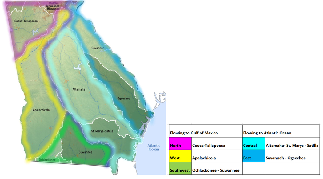
Gulf of Mexico Flows
|
To Gulf of Mexico
|
Petroleum Spills*
|
Toxic/Other/?
|
Water Impact
|
|
Gulf North
|
|
|
|
|
Tennessee
|
0
|
1
|
0
|
|
Coosa
|
0
|
2
|
1
|
|
Tallapoosa
|
0
|
1
|
0
|
|
Gulf West
|
|
|
|
|
Chattahoochee
|
2
|
1
|
1
|
|
Flint
|
1
|
0
|
0
|
|
Gulf Southwest
|
|
|
|
|
Ochlockonee
|
0
|
0
|
0
|
|
Suwannee
|
0
|
0
|
0
|
|
Totals
|
3
|
5
|
2
|
Table updated June 2 2023
1 Gulf North

1a Tennessee River Watershed
The Tennessee River collects rainfall and runoff for the Ohio River system, which joins the Mississippi and empties out into the Gulf of Mexico. While no part of the Tennessee River itself passes through Georgia, there are tributary creeks originating in north Georgia that cross the state line and join up with Tennessee waters.
Spills (0 new)
- No new spills reported for the search period May 22nd – 28th 2023
1b Coosa River Watershed
The Coosa River is a collection of several tributary rivers gathered from northwest Georgia. At the beginnings of this system, the Conasauga River and Coosawattee Rivers join up to form the Oostanaula River. The Oostanaula in turn joins flow with Etowah River system to form the Coosa River. The Coosa runs west into Alabama where it merges with the Tallapoosa River across the state line in Alabama, forming the Alabama River, eventually reaching the Gulf of Mexico.
(Confusion alert** Watch for another river by the same name (Chattooga) in northeast Georgia! These two are not the same.)
Spills (2 new)
- May 1 - unknown amounts of septic waste being discharged onto Seabolt Branch on Cooper Creek Rd in Suches – Union
- May 19 – Fish kill noted in a stream off Benbrook Lane in Marietta – Cobb *
1c Tallapoosa River Watershed
The Tallapoosa River originates in northwest Georgia, draining an area of Paulding and Haralson counties before crossing the state line and joining the Coosa River, forming the Alabama River.
Spills (1 new)
- May 17 - unknown amounts of raw sewage reported spilled onto the ground at a private residence due to no septic system on North Prospect Ave in Waco - Carroll

2 Gulf West
2a Chattahoochee River Watershed
The Chattahoochee headwaters form up near Helen in northeast Georgia, in the Appalachian Mountains. From Union County, the Chattahoochee flows southwest through the capital Atlanta, and then south, forming the state border with Alabama, terminating in Lake Seminole.
Spills (3 new)
- May 21 - 600 gallons of wastewater reported spilled into Flat Creek on Swann Dr in Gainesville – Hall *
- May 16 - 100 gallons of diesel reported spilled from a broken fuel filter housing on a locomotive on Marion Rd in Atlanta – Fulton
- May 16 - unknown amounts of diesel - gas - anti freeze and oil reported spilled from a salvage yard on Clubhouse Rd in Coleman - Randolph
2b Flint River Watershed
The Flint River originates south of Atlanta and gathers run-off from 7570 sq miles of Georgia as it traverses the course north to south, flowing west through Alabama to empty in the Gulf of Mexico.
Spills (1 new)
- May 23 - 7 gallons of transformer oil reported spilled from a vehicle crashing into a pole mounted transformer on Riverdale Rd in Atlanta - Clayton

3 Gulf Southwest
3a Ochlockonee River Basin
Ochlockonee River originates in Worth County in southwest Georgia. The Ochlockonee catchment area drains a combined 1400 plus square miles of Georgia landscape before exiting into Florida and emptying into the Gulf of Mexico. Main use is for fishing. Two smaller and separate watersheds within the Ochlockonee basin, the Aucilla and Wards Creek each have their separate channels directly dumping into the Gulf of Mexico (not monitored). The main tributary rivers and creeks are the Little Ochlockonee River, Tired Creek, Telogia Creek and Crooked River (not monitored).
Spills ( 0 new)
- No new spills reported for the search period May 22nd – 28th 2023
3b Suwannee River Watershed
The Suwanee River originates in the Okefenokee Wilderness, between State Hwy 122 and Valdosta Highway. The blackwater Suwannee and its major tributaries, the Willacoochee, Withlacoochee, Alapaha and Little Rivers channel run-off from more than 5000 sq miles from parts of twenty counties in Georgia before crossing over into Florida to empty into the Gulf of Mexico.
Spills (0 new)
- No new spills reported for the search period May 22nd – 28th 2023

|
To Atlantic Ocean
|
Petroleum Spills*
|
Toxic/Other/?
|
Water Impact
|
|
Atlantic Central
|
|
|
|
|
Oconee
|
0
|
0
|
0
|
|
Ocmulgee
|
0
|
0
|
0
|
|
Altamaha
|
0
|
0
|
0
|
|
Satilla
|
0
|
0
|
0
|
|
St. Marys
|
0
|
0
|
0
|
|
Atlantic East
|
|
|
|
|
Savannah
|
0
|
0
|
0
|
|
Ogeechee
|
0
|
0
|
0
|
|
Totals
|
0
|
0
|
0
|
Table updated June 2 2023
4 Atlantic Central
4a Oconee River Watershed
The Oconee headwaters form in Hall County, flowing southeast through Middle and North Oconee Channels to form the Oconee River below Athens. From here the system flows into Lake Oconee, formed by the Wallace Dam and Sinclair Lake formed by the Sinclair Dam. The Oconee flows down from the dams to its confluence Ocmulgee River, eventually emptying into the Atlantic.
Spills ( 0 new)
- No new spills reported for the search period May 22nd – 28th 2023
4b Ocmulgee River Watershed
Ocmulgee River originates at Jackson Lake, straddling Jasper, Newton and Butts Counties. The Ocmulgee flows south to join the Oconee River, forming the Altamaha River. Jackson Lake is fed by three rivers: South, Yellow and Alcovy Rivers originating in Central Georgia, all part of the Ocmulgee Watershed area.
Spills (0 new)
- No new spills reported for the search period May 22nd – 28th 2023
4c Altamaha River Watershed
The combined flows of the Oconee River system and the Ocmulgee River system form the Altamaha, “the largest free flowing river on the East coast”, according to the Georgia River Network.
Spills (0 new)
- No new spills reported for the search period May 22nd – 28th 2023
4d Satilla River Watershed
The Satilla River forms in Ben Hill County, flows south 200 miles to the Atlantic Ocean.
Hazardous Algae Blooms (HABs) Beach Alerts (0)
Spills ( 0 new)
- No new spills reported for the search period May 22nd – 28th 2023
4e St. Marys River Watershed
St. Marys is a blackwater river originating in the Okefenokee Wilderness area, southcentral Georgia. The river flows 130 miles and empties into Cumberland Sound in the Atlantic.

Hazardous Algae Blooms/Beach Alerts (0 active)
Spills (0 new)
- No new spills reported for the search period May 22nd – 28th 2023
Atlantic East
5a Savannah River Watershed
The Savannah River originates in South Carolina, formed with the combined flows of the Tugaloo, itself formed by the joining of Chattooga and Tallulah Rivers, and the Seneca River. The Savannah flows through east Georgia to its outlet at the Atlantic Ocean, taking run-off from an area of 5800 square miles in Eastern Georgia.
Spills (0 new)
- No new spills reported for the search period May 22nd – 28th 2023
5b Ogeechee River Watershed
The Ogeechee is a free flowing blackwater river draining an area of 5540 sq miles entirely inside the state of Georgia. The North and South Fork Ogeechee Rivers (not monitored) come together to form the Ogeechee, which flows 245 miles and empties in the Atlantic.
Spills (0 new)
- No new spills reported for the search period May 22nd – 28th 2023
Report Key
WTGA reports spills from incident files uploaded to the Georgia EPD Public Complaints portal. Oil, diesel, gas, hazardous materials and sewage spills are posted by the date received, however these are not available to the public until the incident response is complete and the file is closed. Each week WTGA searches thirty days back for new spill reports added to the database and lists them here by watershed area, including:
- Spills of petroleum products of 40 gallons or more,
- spills of any amount impacting water
- spills of any amount of toxic contaminants
These incidents are listed by the watershed in which they occurred.
Spills marked with asterisk * are tracked with state and/or EPA authorities for more information. See the CrimeBox for details on violations and charges under the Clean Water Act.
As per EPA Oil Discharge Reporting Requirements,
the reportable amount of spilled oil product is any amount that leaves a visible sheen on the surface, or a sludge at the bottom of the water body.
- Such spills are to be reported immediately (within 15 minutes)
- 1-800-241-4113 Georgia EPD 24 hour Emergency Operations Center
- Spills from a vessel into navigable waterways
- National Response Center (NRC) at 1-800-424-8802
- 24-hour emergency line staffed by US Coast Guard
- All spills should be cleaned up, whether or not they are reportable.
- From Georgia EPD Emergency Operations Centre, “oil” includes but is not limited to: gasoline, crude oil, fuel oil, diesel oil, lubricating oil, sludge, oil refuse, oil mixed with wastes, and any other petroleum related product.
- Accidental discharges of oil during maintenance of one’s own personal vehicle or farm machinery shall be exempt from the reporting requirement.