Georgia Gulf With the Flow Report for week of May 29 to June 4, 2023
Below normal flows in Flint River watershed
Georgia’s landscape sends rainfall in two directions from the height of land, also known as the drainage divide: southwest to the Gulf of Mexico, or southeast to the Atlantic Ocean.
Find your location in one of Georgia’s Gulf watersheds and track potential impacts to your water supply:
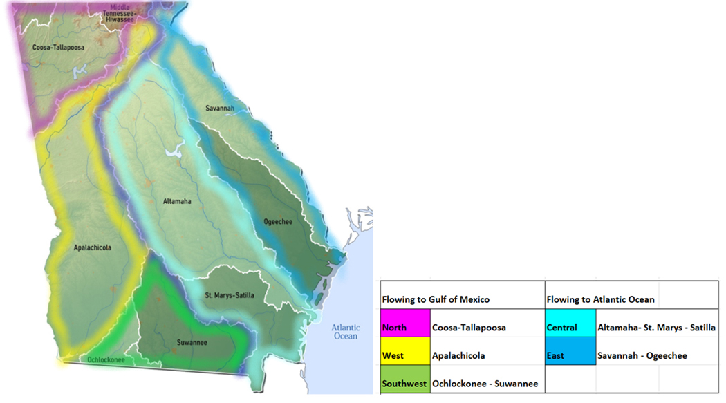
Georgia’s landscape sends rainfall in two directions from the height of land, also known as the drainage divide: southwest to the Gulf of Mexico, or southeast to the Atlantic Ocean.
Find your location in one of Georgia’s Gulf watersheds and track potential impacts to your water supply:
|
Gulf North
|
Low Flows
|
High Flows
|
Drinking Water Advisories
|
Impaired Water Bodies
|
HABs/Beach Alerts
|
Hazardous
Spills
|
|
Tennessee
|
1
|
0
|
0
|
167
|
0
|
1
|
|
Coosa
|
0
|
0
|
0
|
408
|
0
|
3
|
|
Tallapoosa
|
0
|
0
|
0
|
54
|
0
|
1
|
|
Totals
|
1
|
0
|
0
|
629
|
0
|
5
|
Table updated June9, 2023
Gulf of Mexico Flows
1 Gulf North
1a Tennessee River Watershed
The Tennessee River collects rainfall and runoff for the Ohio River system, which joins the Mississippi and empties out into the Gulf of Mexico. While no part of the Tennessee River itself passes through Georgia, there are tributary creeks originating in north Georgia that cross the state line and join up with Tennessee waters.
Lookout Creek drains an area of 149 sq miles of Dade County. The flow is monitored near New England: normal flow at this station is around 280 cfs and 5.4 ft deep. Minor flooding occurs at 12 feet.
Chattanooga Creek drains an area of 6 sq miles of Walker County. The flow is monitored at Flintstone, has been around 80 cfs and 4.5 ft deep.
West Chickamauga Creek drains an area of 148 sq miles in Catoosa County. The flow is monitored near Lakeview: has been around 250 cfs and close to 3 ft deep.
South Chickamauga Creek drains an area of 169 sq miles in Catoosa County. The flow is monitored near Ringgold: has been measured in this location at around 250 cfs and 5 ft deep. (04-18-23)
Low Flows (1) June 4 8:00 am EDT
Nottely River is flowing much below normal near Blairsville - 1.81 ft deep at 86.9 cfs
Drinking Water Advisories (0)
Impaired Water Body EPA 303d List (167)
- 167 water bodies or sections of water bodies, including rivers, creeks, streams, lakes and reservoirs not meeting desired use or having measured contaminant above threshold levels are listed on Georgia’s IWB 303d list for 2020. See this site for the detailed list under the Gulf North Tab, for Tennessee Watershed.
Hazardous Algae Blooms (HABs) Beach Alerts (0)
Spills (1)
· May 1 - unknown amount of septic waste reported discharged onto Seabolt Branch on Cooper Creek Rd in Suches - Union
1b Coosa River Watershed
The Coosa River is a collection of several tributary rivers gathered from northwest Georgia. At the beginnings of this system, the Conasauga River and Coosawattee Rivers join up to form the Oostanaula River. The Oostanaula in turn joins flow with Etowah River system to form the Coosa River. The Coosa runs west into Alabama where it merges with the Tallapoosa River across the state line in Alabama, forming the Alabama River, eventually reaching the Gulf of Mexico.
(Confusion alert** Watch for another river by the same name (Chattooga) in northeast Georgia! These two are not the same.)
Conasauga River drains an area of 8.24 sq miles in Murray County. Normal flow at Tilton is around 1000 cfs and 4.7 ft deep.
Mill Creek drains an area of 40 sq miles in Whitfield County. Normal flow at Dalton is around 60 cfs and 4.5 ft deep.
Coahulla Creek drains an area of 176 sq miles in Whitfield County. Normal flow near Dalton is around the 244 cfs mark and 8.8 ft deep.
Coosawattee River drains an area of 831 sq miles in Gordon and Murray Counties. Normal flow at Pine Chapel is right around the 2100 cfs mark, and 8.5 ft deep.
Talking Rock Creek drains an area of 119 sq miles. Normal flow near Hinton is right around 170 cfs and 1.5 feet deep.
Holly Creek drains an area of 1602 sq miles in Gordon County. The normal flow near Chatsworth is 100 cfs and 2.5 ft deep. The water temp is monitored at this station.
Fausett Creek drains an area of 9.99 sq miles in Gilmer County. Normal flow near Talking Rock is 10 cfs and 1.5 ft deep.
Oostanaula River drains an area of 2115 sq miles in Gordon and Floyd Counties. Normal flow at Resaca is around 3400 cfs and 7 ft deep.
Etowah River drains an area of 1634 sq miles in Dawson, Bartow and Cherokee Counties.
- The flow at GA 136 near Landrum is around 250 cfs and 2.8 ft deep (flood stage is 14 ft); temperature and specific conductance are measured here
- at GA9 near Dawsonville a normal flow is around 320 cfs and 5 ft deep (flood stage is 13 ft) temperature and specific conductance are measured here
- at Kelly Bridge near Matt the normal flow is around 670 cfs and 2.5 ft deep (flood stage is 19 ft);
- normal flow downstream of I-575 at Canton in Cherokee County is 1250 cfs ad 5 ft deep (flood stage is 17 ft);
- at Canton the normal flow is under 4000 cfs and 4 ft deep (flood stage is 16 ft) temperature is monitored here;
- at Allatoona Dam above Cartersville in Bartow County, flow is variable, as the water is released on a regular cycle it fluctuates but is not allowed to get to flood stage. Normal flow is less than 4000 cfs and 4 ft deep (flood at 9ft) temperature is monitored here.
- at Allatoona Dam the water is normally around 690 ft deep;
- at GA61 near Cartersville a normal flow is around 4000 cfs and 9.8 ft deep (flood stage is 18 ft);
- near Kingston, normal flow volume is 1500 cfs and 4.5 ft deep (floods at 20 ft) (04-18-23)
Two Run Creek drains an area of 33.1 sq miles in Bartow County. Normal flow near Kingston is 60 cfs and 1.5 ft deep.
Oothcalooga River drains an area of 62.6 sq miles in Gordon County. The normal flow rate at GA 53 spur near Calhoun is around 130 cfs and 7.7 ft deep.
Coosa River drains an area of 4040 sq miles in Floyd County. Normal flow near Rome is 5600 cfs and 12.8 ft deep (flood stage is 24 ft). The water temp is monitored at this station.
Chattooga River (of the northwest) drains an area of 4040 sq miles of northwest Georgia. Normal flow at Summerville is around 400 cfs and 3.8 ft deep (flood stage is 14 ft)
Low Flows (1)
Drinking Water Advisories (0)
Impaired Water Body EPA 303d List (408)
- 408 water bodies or sections of water bodies, including rivers, creeks, streams, lakes and reservoirs not meeting desired use or having measured contaminant above threshold levels are listed on Georgia’s IWB 303d list for 2020. See this site for the detailed list under the Gulf North Tab, for Coosa Watershed.
Hazardous Algae Blooms (HABs) Beach Alerts (0)
Spills (2)
- May 24 - unknown amounts of sewage reported spilled from an overflowing manhole on Savannah Place in Rome - Floyd
- May 19 – Fish kill noted in a stream off Benbrook Lane in Marietta – Cobb *
1c Tallapoosa River Watershed
The Tallapoosa River originates in northwest Georgia, draining an area of Paulding and Haralson counties before crossing the state line and joining the Coosa River, forming the Alabama River.
Tallapoosa River drains an area of 272 sq miles of Haralson County. Normal flow at US78 near Tallapoosa can be 400 cfs and 3 ft deep as of 02/16/23
Little Tallapoosa drains an area of 245 sq miles of Carroll County. Normal flow at GA100 near Bowden can be 500 cfs 6 ft deep; Normal flow at Carrollton can be 200 cfs and 4 ft deep as of 03/24/23
Cedar Creek drains an area of 65.3 sq miles of Polk County. Normal flow at Cedartown is around 200 cfs and 2 ft deep as of 03/24/23
Snake Creek drains an area of 35.5 sq miles of Carroll County. The flow near Whitesburg is normal, 104.18% above mean at 59.8 cfs and 2.2 ft deep as of 02/16/23
Snake Creek Reservoir drains an area of 34 sq miles in Carroll County. Normal flow is 113.72 % above mean at 55.7 cfs and 4 ft deep. The water temp is 10.5 °C as of 02/16/23
Dog River drains an area of 66 sq miles of Douglas County. Normal flow at GA 5 near Fairplay 81.11% above mean at 112 cfs and 4 ft deep. The water temp is 13.1 °C. 02/16/23
High Flows (0), Flood (0)
Drinking Water Advisories (0)
Impaired Water Body EPA 303d List (54)
- 54 water bodies or sections of water bodies, including rivers, creeks, streams, lakes and reservoirs not meeting desired use or having measured contaminant above threshold levels are listed on Georgia’s IWB 303d list for 2020. See this site for the detailed list under the Gulf North Tab, for Tallapoosa River Watershed.
Hazardous Algae Blooms (HABs) Beach Alerts (0)
Spills (1)
- May 17 - unknown amounts of raw sewage reported spilled onto the ground at a private residence due to no septic system on North Prospect Ave in Waco - Carroll
|
Gulf West
|
Low Flows
|
High Flows
|
Drinking Water Advisories
|
Impaired Water Bodies
|
HABs/Beach Alerts
|
Hazardous Spills
|
|
Chattahoochee
|
1
|
0
|
1
|
403
|
0
|
3
|
|
Flint
|
1
|
0
|
1
|
263
|
0
|
1
|
|
Totals
|
2
|
0
|
2
|
669
|
0
|
4
|
Table updated June 9, 2023

2 Gulf West
2a Chattahoochee River Watershed
The Chattahoochee headwaters form up near Helen, in northeast Georgia in the Appalachian Mountains. From Union County, the Chattahoochee flowing southwest, through the capital and then south, forming the state border with Alabama, terminating in Lake Seminole.
Chattahoochee River drains an area of 8210 sq miles from the northeast to the southwest state
- At Helen normal flow is around 120 cfs and 1 ft deep, (flood stage 6 ft) temperature is recorded here;
- at Leaf normal flow is around 400 cfs and 2.2 ft deep;
- near Cornelia, normal flow is around 800 cfs and 1.5 ft deep (flood stage 14 ft);
- At Buford Dam near Buford, normal flow is less than 5000 cfs and 3 ft deep; minor flood stage at this location is 12 ft. Water temperature is measured here;
- At US McInnes Freeway at Suwanee normal flow is around 7800 and 10 ft deep (flood stage is 22ft)
- near Norcross normal flow is around 1000 cfs and 2 ft deep (flood stage is 12 ft)
- above Roswell, normal flow is around 1100 cfs and 3.3 feet deep (flood stage is 9 ft)
- below Morgan Falls Dam normal flow is around 2000 cfs and 800 ft deep (flood stage is 821 ft)
- At Atlanta, normal flow is 2400 cfs and 4.5 ft deep (minor flood stage 14 ft)
- At GA 280 near Atlanta, normal flow is around 3300 cfs and 8.5 ft deep (minor flood stage 24 ft)
- near Fairburn, normal flow is around 5600 cfs and 5 ft deep (flood stage is 20 ft)
- near Whitesburg, normal flow is around 5000 cfs and 6 ft deep (flood stage is 17 ft)
- at GA100 at Franklin, the flow is unrated, we see this around 5000 cfs and 12 ft deep (flood stage 23 ft)
- at West Point, normal flow is below 15000 cfs and 7 ft deep (flood stage is 17 ft)
- below West Point Dam, normal flow is 565 ft deep
- 14th St at Columbus, normal flow is around 9000 cfs and 21 ft deep (flood stage is 27 feet);
- At spur 39 near Omaha, normal flow is around 12000 cfs and 187 feet deep;
- Below WFG Dam above Ft Gaines, flow is unrated, commonly found around 110 feet deep (flood stage is 134 ft deep)(updated 04-18-23)
Powder Springs Creek drains an area of 23 sq miles of Cobb County. Normal flow near Powder Springs is around 30 cfs and 1.8 ft deep (04-18-23)
Noses Creek drains an area of 44.5 sq miles of Cobb County. Normal flow at Powder Road is around 45 cfs and 2.5 ft deep (flood stage is 11 ft) (04-18-23)
Sweetwater Creek drains an area of 13.5 sq miles of Cobb County. Normal flow at Powder Springs is around 180 cfs and 5 ft deep (04-18-23)
Nickajack Creek drains an area of 31 sq miles in Cobb County. Normal flow near Mableton is around 30 cfs and 2 ft deep (flood stage is 10 ft) (04-18-23)
Utoy Creek drains an area of 33 sq miles in Fulton County. Normal flow is around 50 cfs and 3 ft deep. The water temp is recorded at this site (04-18-23)
Nancy Creek drains an area of 26.6 sq miles in DeKalb County. Normal flow at Johnson Ferry Rd at Chamblee is Atlanta is around 20 cfs and 4.5 ft deep (flood stage 16 ft). The water temp is recorded at this station (04-18-23)
Low Flow (1) June 4 8:00 am EDT
Chattahoochee River is flowing much below normal at West Point - 2.55 ft deep at 845 cubic feet per second
Drinking Water Advisories (1)
May 9 - Forsyth County – Boil Water Advisory issued for customers along Post Road. Government officials advise to expect outages in water supply with the boil advisory taking effect 10 p.m. on Tuesday May 9 as crews work to repair a water valve leak.
Impaired Water Body EPA 303d List (403)
- 403 water bodies or sections of water bodies, including rivers, creeks, streams, lakes and reservoirs not meeting desired use or having measured contaminant above threshold levels are listed on Georgia’s IWB 303d list for 2020. See this site for the detailed list under the Gulf West Tab, for Chattahoochee River Watershed.
Hazardous Algae Blooms (HABs) Beach Alerts (0)
Spills (3)
- May 21 - 600 gallons of wastewater reported spilled into Flat Creek on Swann Dr in Gainesville - Hall
- May 16 - 100 gallons of diesel reported spilled from a broken fuel filter housing on a locomotive on Marion Rd in Atlanta – Fulton
- May 16 - unknown amounts of diesel - gas - anti freeze and oil reported spilled from a salvage yard in Coleman - Randolph
2b Flint River Watershed
The Flint River originates south of Atlanta and gathers run-off from 7570 sq miles of Georgia as it traverses the course north to south, flowing west through Alabama to empty in the Gulf of Mexico.
Flint River drains an area of 7570 sq miles down the west side of the state.
- normal flow near Lovejoy is around 100 cfs and 2.5 ft deep (flood stage is 12 ft)
- normal flow at Woolsey Rd near Woolsey is around 120 cfs and 39 ft deep (flood stage is 45 ft)
- normal flow at Griffin in Spalding County is around 220 cfs and 4 ft deep (flood stage is 12 ft)
- below Big Branch, near Molena in Pike County normal flow is around 700 cfs and 6.5 ft deep (flood stage is 28 ft)
- at Thomaston, Upson County, normal flow is around 1600 cfs and 4 ft deep (flood stage is 11 ft)
- near Carsonville in Upson County normal flow is around 2300 cfs and 4.6 ft deep (flood stage 18 ft)
- at GA 26 near Montezuma, Macon County, normal flow is around 4000 cfs and 6 ft deep (flood stage is 20 ft)
- at GA 32 near Oakfield in Worth County, normal flow is around 4600 cfs and 6 ft deep (flood stage 23 ft)
- at Albany, Dougherty County, normal flow is around 5500 cfs and 5.5 ft deep (flood stage 26 ft)
- at Newton in Baker County, normal flow is 6500 cfs and 8 ft deep (flood stage is 24 ft)
- at Riverview Plantation near Hopeful in Mitchell County, normal flow is 8000 cfs and 9 ft deep (flood stage is 30 ft)
- at Bainbridge, Decatur County normal flow is around 9500 cfs and 19 ft deep (flood stage 25 ft). Temperature is recorded at this station. (04-18-23)
Low Flows (1) as of June 4, 2023
Flint River is flowing much below normal at GA 32 near Oakfield - 2.68 feet deep at 922 cubic feet per second
Drinking Water Advisories (1)
May 12 – Sasser (Terrell) Boil Water Advisory letter has gone out to residents of Sasser advising of the need to boil water beginning 8:00 am May 15 until further notice while construction work is done on a distribution system.
Impaired Water Body EPA 303d List (263)
- 263 water bodies or sections of water bodies, including rivers, creeks, streams, lakes and reservoirs not meeting desired use or having measured contaminant above threshold levels are listed on Georgia’s IWB 303d list for 2020. See this site for the detailed list under the Gulf West Tab, for Flint River Watershed.
Hazardous Algae Blooms (HABs) Beach Alerts (0)
Spills (1)
- May 23 - 7 gallons of transformer oil reported spilled from a vehicle crashing into a pole mounted transformer on Riverdale Rd in Atlanta - Clayton
|
Gulf Southwest
|
Low Flows
|
High Flows
|
Drinking Water Advisories
|
Impaired Water Bodies
|
HABs/Beach Alerts
|
Hazardous Spills
|
|
Ochlockonee
|
0
|
0
|
0
|
45
|
0
|
0
|
|
Suwannee
|
0
|
0
|
0
|
127
|
0
|
0
|
|
Totals
|
0
|
0
|
0
|
172
|
0
|
0
|
Table updated June 4, 2023
3 Gulf Southwest
3a Ochlockonee River Basin
Ochlockonee River originates in Worth County in southwest Georgia. The Ochlockonee catchment area drains a combined 1400 plus square miles of Georgia landscape before exiting into Florida and emptying into the Gulf of Mexico. Main use is for fishing. Two smaller and separate watersheds within the Ochlockonee basin, the Aucilla and Wards Creek each have their separate channels directly dumping into the Gulf of Mexico (not monitored). The main tributary rivers and creeks are the Little Ochlockonee River, Tired Creek, Telogia Creek and Crooked River (not monitored).
- Ochlockonee River drains an area of 1002 sq miles in Worth, Thomas and Leon counties.
- Normal flow at GA188 near Coolidge in Thomas County is around 1300 cfs and 10.5 ft deep (floods at 13 ft);
- near Thomasville in Thomas County normal flow is around 2200 cfs and 12 ft deep (floods at 15 ft);
- near Concord, at the Georgia/Florida border in Leon County normal flow is around 5000 cfs and 35 feet deep (flood stage is 36 ft). (updated 04-18-23)
Low Flows (0)
Drinking Water Advisories (0)
Impaired Water Body EPA 303d List (45)
- 45 water bodies or sections of water bodies, including rivers, creeks, streams, lakes and reservoirs not meeting desired use or having measured contaminant above threshold levels are listed on Georgia’s IWB 303d list for 2020. See this site for the detailed list under the Gulf Southwest Tab, for Ochlockonee River Watershed.
Hazardous Algae Blooms (HABs) Beach Alerts (0)
Spills (0)
3b Suwannee River Watershed
The Suwanee River originates in the Okefenokee Wilderness, between State Hwy 122 and Valdosta Highway. The blackwater Suwannee and its major tributaries, the Willacoochee, Withlacoochee, Alapaha and Little Rivers channel run-off from more than 5000 sq miles from parts of twenty counties in Georgia before crossing over into Florida to empty into the Gulf of Mexico.
Suwannee River drains 1130 sq miles in south central Georgia.
- Normal flow above Fargo in Clinch County runs around 6ft deep;
- at US 441 at Fargo in Clinch County normal flow is around 250 cfs and 3.5 ft deep. The channel floods at 13 ft in this location. (update 04-18-23)
Little River drains an area of 776 sq miles in Georgia before joining the Withlacoochee. The Little River is flowing
- at Upper Ty Ty Road near Tifton in Tift County the flow is unrated, often runs around 40 cfs, and 1 ft deep;
- near Adel in Cook County normal flow is around 150 cfs and 3.5 ft deep (flood stage is 15.9 ft);
- at GA 122 near Hahira in Lowndes the flow is unrated, often around 200 cfs and 7 ft deep. Flooding occurs at 15.2 ft at this section of the river. (update 04-18-23)
Alapaha River drains an area of 1730 sq miles of south-central Georgia.
- at GA 195/32 near Irwinville in Irwin County flow is unrated, it is often around 20 cfs and 2.2 feet deep (flood stage is 9.9 ft);
- near Alapaha normal flow is around 300 cfs and 5.5 feet deep (flooding occurs at 15.4 ft);
- at Statenville in Echols County normal flow is around 1000 cfs and 5.5 feet deep (flood stage is 23.9 ft at this location) (Update 04-18-23)
Withlacoochee River drains an area of 1480 sq miles. The flow at
- Skipper Bridge Rd near Bemiss in Lowndes County normal flow is around 130 cfs and 4 ft deep (flood stage is 14.7 ft);
- US 41 near Valdosta flow is unrated, often measuring 7 ft deep;
- at US 84 near Quitman, normal flow is around 500 cfs and 4 ft deep (flood stage at 20.5 ft) temp and conductance values are available here;
- near Pinetta, Florida normal flow is around 1000 cfs and 8 ft deep, (flood stage 26.5 ft) temperature and conductance are measured here (04-18-23)
Low Flows (0) High Flows (0)
Drinking Water Advisories (0)
Impaired Water Body EPA 303d List (127)
- 127 water bodies or sections of water bodies, including rivers, creeks, streams, lakes and reservoirs not meeting desired use or having measured contaminant above threshold levels are listed on Georgia’s IWB 303d list for 2020. See this site for the detailed list under the Gulf Southwest Tab, for Suwannee River Watershed.
Hazardous Algae Blooms (HABs) Beach Alerts (0)
Spills (0)
Flows
WTGA describes the stream flows in each watershed, including direction/path of flow, listing monitoring stations in order from headwaters to outlet, indicating the seasonal normal flow volume in cubic feet per second (cfs), the gage height (flow depth) during normal conditions and the flood stages, or the gage height at which flooding will occur. Locate your “home body” (the river or stream nearest you) to see where the flow originates, how high the flow must be for minor flooding to occur. Log in to USGS Waterwatch current streamflow for real time measurements at the monitoring station nearest you and sign up there for high flow alerts.
Flow volume can change rapidly during rain events, check your local upstream station flow levels at the USGS WaterWatch Current Streamflow site, or sign up for high flow alerts to your mobile device. Streamflow data is subject to review as sensors at the monitoring stations do malfunction from time to time. See USGS Provisional Data Statement at the end of this report for more information.
EPA Impaired Water Bodies 303d List
The EPA requires all states update a draft list of impaired water bodies (the 303d list) every two years; providing a period for public comments, presenting the draft list to the EPA. The final 303d list is published as approved by the EPA, roughly every two years.
Impaired water bodies are defined as those with contaminants measured above threshold levels, as set by the EPA Clean Water Act, or where the desired use is impaired. The 2020-2022 Draft list includes Georgia lakes, creeks, rivers and reservoirs that recommended for Total Maximum Daily Load (TMDL) plans. The TMDL plan is a type of Clean Water Plan, established by a collaboration of municipal, industrial and environmental groups in an overlay zoning district.
Hazardous Algae Blooms (HABs) Beach Alerts –
Hazardous algae blooms are reported here as they are confirmed across the state
Contact parks management for the current information on local conditions before heading out and consider using an on-site rapid test for microcystin toxin.
Drinking Water Advisories
Boil Water and Do not Consume advisories issued by drinking water facilities for various reasons, short term disruptions due to water main breaks, repairs, loss of pressure are posted here by watershed area.
Hazardous Spills
1-800-241-4113 Georgia EPD 24 hour Emergency Operations Center
National Response Center: 1-800-424-8802 – Coast Guard for spill incidents on water
Reporting from the latest records uploaded to the Georgia spill incidents database
Spills of petroleum products of 40 gallons or more are listed weekly in the watershed in which they occur, citing location of the spill, the contaminant spilled (if known), the quantity (if known) and the resource affected (if known) surface water, groundwater, sewer, etc, and any amounts recovered at the site.
Spills over 100 gal, very toxic chemical spills and spills that impact state waters are flagged and followed up with the spiller, the state and/or EPA authorities for more information, these are marked with asterisk.*
See Spills Tracker for more information on these spills as it becomes available.
Sources
WaterToday Georgia aggregates information and data from Georgia Environmental Protection Division, Department of Health, Region 4- EPA, USGS, NWS, NOAA by watershed area. The accuracy of the information contained in our reports is dependent on these sources. Provisional data statements apply, confirm data with local authorities before taking action.
| 

