Georgia Atlantic With the Flow Report for week of May 29 to June 4, 2023
Below normal flows in the north
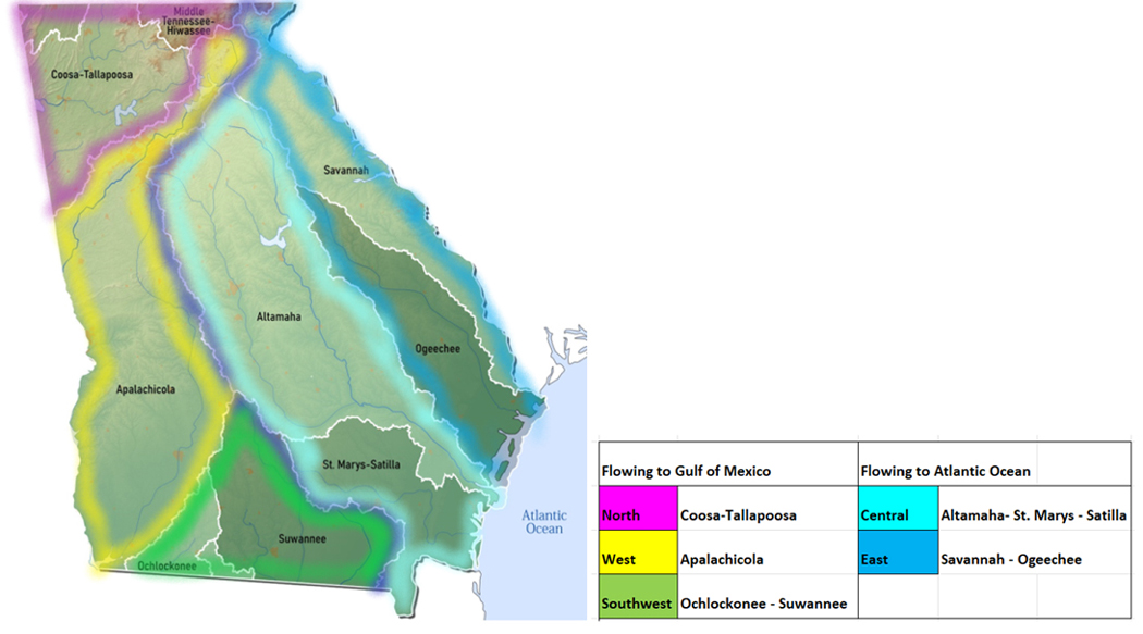
Recording water events and impacts from the drainage divide flowing south and east to Atlantic Ocean
Find your location in the watersheds of the Atlantic drainage area:
|
Atlantic Central
|
Low Flows
|
High
Flows
|
Drinking Water Advisories
|
Impaired Water Bodies
303d list ‘22
|
HABs/Beach Alerts
|
Hazardous Spills
|
|
Oconee
|
0
|
0
|
0
|
278
|
0
|
0
|
|
Ocmulgee
|
1
|
0
|
1
|
281
|
0
|
0
|
|
Altamaha
|
0
|
0
|
0
|
71
|
0
|
0
|
|
Satilla
|
1
|
1
|
0
|
121
|
0
|
0
|
|
St. Marys
|
0
|
0
|
0
|
14
|
0
|
0
|
|
Totals
|
1
|
1
|
1
|
765
|
0
|
0
|
Chart updated June 9, 2023

4 Atlantic Central
4a Oconee River Watershed
The Oconee headwaters form in Hall County, flowing southeast through Middle and North Oconee Channels to form the Oconee River below Athens. From here the system flows into Lake Oconee, formed by the Wallace Dam and Sinclair Lake formed by the Sinclair Dam. The Oconee flows down from the dams to its confluence Ocmulgee River, eventually emptying into the Atlantic.
- Middle Oconee drains an area of 398 sq miles in Jackson and Clarke Counties before joining the North Oconee stream to form Oconee River.
- North Oconee drains an area of 275 sq miles of Jackson and Clarke Counties before joining up with Middle Oconee below Athens.
- at Commerce normal flow is around 150 cfs and 3 ft deep (flood stage is 15 ft);
- at Athens, flow is unrated, around 650 cfs and 2 ft deep (floods at 19 ft) (04-18-23)
- Oconee River drains an area of 5110 sq miles of Wheeler, Laurens, Wilkinson, Baldwin, Greene and the above Counties. The flow monitor
- near Penfield in Greene County normal flow is around 1500 cfs and 6 ft deep (floods at 13 ft);
- at Milledgeville in Baldwin County normal flow is around 3500 cfs and 10 ft deep (flood stage 30 ft);
- at Avant Mine near Oconee in Washington County normal flow is around 4400 cfs and 8 ft deep (floods at 18 ft);
- near Oconee in Wilkinson County flow is unrated, often measuring around 7800 cfs and 12.5 ft deep (flood stage 17 ft);
- at Dublin in Laurens County normal flow is around 8000 cfs and 12 feet deep (flood stage is 21 ft);
- near Mt. Vernon in Wheeler County normal flow is around 10000 cfs and 12 ft deep (flood stage is 16 ft)
(updated 04-18-23)
Low Flow (0)
Drinking Water Advisories (0)
Impaired Water Body EPA 303d List (281)
- 281 water bodies or sections of water bodies, including rivers, creeks, streams, lakes and reservoirs not meeting desired use or having measured contaminant above threshold levels are listed on Georgia’s IWB 303d list for 2020. See this site for the detailed list under the Atlantic Central, for Oconee River Watershed.
Hazardous Algae Blooms (HABs) Beach Alerts (0)
Spills (0)
4b Ocmulgee River Watershed
Ocmulgee River originates at Jackson Lake, straddling Jasper, Newton and Butts Counties. The Ocmulgee flows south to join the Oconee River, forming the Altamaha River. Jackson Lake is fed by three rivers: South, Yellow and Alcovy Rivers originating in Central Georgia, all part of the Ocmulgee Watershed area.
South River drains an area of 468 sq miles in Newton, Dekalb and Fulton Counties.
- Normal flow at Springdale Rd in Atlanta is 2.5 ft deep (flood stage 17 ft) temp and conductance are taken here;
- at Forrest Park Rd in Atlanta, normal flow is around 40 cfs and 3 ft deep (flood stage 15 ft) temp and conductance are taken here;
- at Flakes Mill Rd near Atlanta in Dekalb County normal flow is around 200 cfs and 3.5 ft deep (flood stage is 13 ft) temp and conductance are taken here;;
- at Klondike Rd near Lithonia in Dekalb County normal flow is around 250 cfs and 5 ft deep (flood stage is 12 ft);
- at GA81 at Snapping Shoals in Newton County normal flow is around 600 cfs and 7 ft deep (flood stage is 12 ft). (Updated 04-18-23
Yellow River drains an area of sq miles in Dekalb and Counties.
- at Pleasant Hill Rd near Lithonia in Dekalb County normal flow is around 400 cfs and 2.5 ft deep (floods at 13 ft);
- at Milstead in Rockdale County normal flow is around 2 ft deep (floods at 13ft);
- at Rocky Plains Rd near Rocky Plains in Newton County, the flow is unrated, often around 700 cfs and 6 ft deep (flood stage 18 ft) (update 04-18-23)
Alcovy River drains an area of 244 sq miles in Newton and Gwinnett Counties.
- at New Hope Rd near Grayson in Gwinnett County normal flow is around 50 cfs and 2.8 ft deep (floods at 9ft) temp and conductance are taken here;;
- above Covington in Newton County normal flow is around 300 cfs and 5 ft deep (flood stage is 12 ft) temp and conductance are taken here;;
- below Covington in Newton County normal flow is around 450 cfs and 3.5 ft deep (floods at 11 ft) (update 04-18-23)
Little Ocmulgee River drains an area of 316 sq miles in Telfair County. The flow
- at GA149 at Scotland in Telfair County is unrated, we see it around 1000 cfs and 9 ft deep (flood stage is 12 ft) (04-18-23)
Ocmulgee River drains a combined area of 5180 sq miles in central Georgia. The flow
- near Jackson in Butts County normal flow is around 2500 cfs and 5.5 ft deep (flood stage 19 ft);
- at Macon in Bibb County normal flow is around 4000 cfs and 11.5 ft deep (flood stage 18 ft);
- at US341 at Hawkinsville in Pulaski County normal flow is around 8000 cfs and 12 ft deep (flood stage 20 ft);
- at Abbeville in Wilcox County normal flow is around 10000 cfs and 10 ft deep (flood stage 12 ft);
- at Lumber City in Jeff Davis County normal flow is around 12000 cfs and 11 ft deep (flood stage 15 ft) (updated 04-18-23 )
Low Flows (1) June 4, 2023
Tobesofkee Creek is flowing much below normal near Macon - 1.97 ft deep at 10.2 cubic feet per second
Drinking Water Advisories (1)
May 15- Monroe County - A boil advisory has been issued by the North Monroe County Water System following an issue with failed motor starter in a pump at the Butts County water plant. The advisory applies to customers on Johnsonville Road and north, except for the River Forest, Riata, and River Walk subdivisions.
Impaired Water Body EPA 303d List (278)
- 278 water bodies or sections of water bodies, including rivers, creeks, streams, lakes and reservoirs not meeting desired use or having measured contaminant above threshold levels are listed on Georgia’s IWB 303d list for 2020. See this site for the detailed list under the Atlantic Central Tab, for Ocmulgee River Watershed.
Hazardous Algae Blooms (HABs) Beach Alerts (0)
Spills (0)
4c Altamaha River Watershed
The combined flows of the Oconee River system and the Ocmulgee River system form the Altamaha, “the largest free flowing river on the East coast”, according to the Georgia River Network.
Altamaha River drains a combined area of 14000 square miles in central Georgia.
- at US221 near Charlotteville in Montgomery County the flow is unrated, we see this around 20000 cfs and 11 ft deep (flood stage 13 ft);
- near Baxley in Appling County normal flow is around 20000 cfs and 10.5 deep (flood at 12.99 ft) temp sensor here;
- at Doctortown in Wayne County normal flow is 24000 cfs and 10 ft deep (floods at 12 ft);
- near Everett City in Glynn County flow is unrated 25000 cfs and 11 ft deep (floods at 13 ft) (updated 04-18-23)
Ohoopee River drains an area of 1110 sq miles in Emanuel and Tatnall Counties.
- at GA 297 near Swainsboro in Emanuel County normal flow is around 2500 cfs and 14 ft deep (flood stage 18 ft);
- near Reidsville normal flow is around 3000 cfs and 8.5 ft deep (flood stage is 10 ft) (updated 04-18-23)
Low Flows (0)
Drinking Water Advisories (0)
Impaired Water Body EPA 303d List (71)
- 71 water bodies or sections of water bodies, including rivers, creeks, streams, lakes and reservoirs not meeting desired use or having measured contaminant above threshold levels are listed on Georgia’s IWB 303d list for 2020. See this site for the detailed list under the Atlantic Central Tab, for Altamaha River Watershed.
Hazardous Algae Blooms (HABs) Beach Alerts (0)
Spills (0)
4d Satilla River Watershed
The Satilla River forms in Ben Hill County, flows south 200 miles to the Atlantic Ocean.
- Little Satilla River drains an area of 659 sq miles in Pierce County. Normal flow near Offerman is less than 1500 cfs and 7 ft deep (flood stage is 9ft) (04-18-23)
- Satilla River drains an area of 3240 sq miles in south central Georgia to the Atlantic. The flow
- at GA 158 near Waycross in Ware County normal flow is around 1000 cfs and 9.5 ft deep (flood stage is reached at 14 ft);
- at Waycross normal flow is around 1500 cfs and 11.5 ft deep (floods at 16 ft)
- at Atkinson in Brantley County, normal flow is around 3000 cfs and 11 ft deep (flood stage 13 ft);
- at Woodbine in Camden County is tidal water, ranging from -30,000 to 30,000 cfs, and less than a foot deep (flood stage is 4.21 ft) (update 04-18-23)
Low Flows (0)
Drinking Water Advisories (0)
Impaired Water Body EPA 303d List (121)
- 121 water bodies or sections of water bodies, including rivers, creeks, streams, lakes and reservoirs not meeting desired use or having measured contaminant above threshold levels are listed on Georgia’s IWB 303d list for 2020. See this site for the detailed list under the Atlantic Central tab, for Satilla Watershed.
Hazardous Algae Blooms (HABs) Beach Alerts (0)
Spills (0)
4e St. Marys River Watershed
St. Marys is a blackwater river originating in the Okefenokee Wilderness area, southcentral Georgia. The river flows 130 miles and empties into Cumberland Sound in the Atlantic.
- North Prong St Marys River drains an area of 160 sq miles in Baker County. Normal flow at Montiac in Bakers County is around 80 cfs and 6.5 ft deep (flood stage is 12 ft) (update 04-18-23)
- Marys River drains an area of 1480 sq miles in south central Georgia, including Baker, Charlton, and Camden Counties. The flow
- near MacClenny in Florida, normal flow is around 200 cfs and 4 ft deep (flood stage is 12 ft);
- at Ferry Landing near Folkston in Charlton County flow is unrated, commonly 1.5 ft deep (flood stage is 7ft);
- the flow at I-95 near Kingsland in Camden County is tidal, flowing in and out to sea at 23500 cfs and ranging from negative to 1.5 feet deep (flood stage is 3.47 ft) (update 04-18-23)
Low Flows (0)
Drinking Water Advisories (0)
Impaired Water Body EPA 303d List (14)
- 14 water bodies or sections of water bodies, including rivers, creeks, streams, lakes and reservoirs not meeting desired use or having measured contaminant above threshold levels are listed on Georgia’s IWB 303d list for 2020. See this site for the detailed list under the Atlantic Central tab, for St. Marys River Watershed.
Hazardous Algae Blooms (HABs) Beach Alerts (0)
Spills (0)
|
Atlantic East
|
Low
Flows
|
High Flows
|
Drinking Water Advisories
|
Impaired Water Bodies
|
HABs/Beach Alerts
|
Hazardous Spills
|
|
Savannah
|
2
|
0
|
0
|
302
|
0
|
0
|
|
Ogeechee
|
0
|
0
|
0
|
116
|
0
|
0
|
|
Totals
|
2
|
0
|
0
|
418
|
0
|
0
|
Table updated June 9, 2023
Atlantic East
5a Savannah River Watershed
The Savannah River originates in South Carolina, formed with the combined flows of the Tugaloo, itself formed by the joining of Chattooga and Tallulah Rivers, and the Seneca River. The Savannah flows through east Georgia to its outlet at the Atlantic Ocean, taking run-off from an area of 5800 square miles in Eastern Georgia.
Chattooga River drains an area of 47 sq miles in Rabun County. Normal flow at Burrells Ford near Pine Mountain is around 150 cfs and 1.3 ft deep, temp is recorded at this station (flood stage is 7 ft) (update 04-18-23)
Tallulah River drains an area of 184 sq miles in Rabun County. Normal flow near Clayton is around 200 cfs and 2.5 ft deep (flood stage is 20ft);
- at Terrora Powerhouse at Tallulah Falls the flow is unrated, we see this around 90 cfs and 2.5 ft deep;
- above Powerhouse near Tallulah Falls flow normal flow is around 40 cfs and 5 ft deep (flood stage is 30 ft) (update 04-18-23)
Broad River drains an area of 1420 sq feet in Elbert and Madison Counties. Normal flow above Carlton in Madison County is around 1000 cfs and 4 ft deep (flood stage is 15 ft);
- near Bell in Elbert County normal flow is around 40 cfs and 5 ft deep (flood stage is 21 ft) 04-18-23
Savannah River drains an area of 9850 sq miles from Columbia County to Effingham County. Normal flow:
- near Evans in Columbia County is around 14 ft deep;
- at Jefferson Davis Bridge near Augusta in Richmond County is 13 ft deep;
- at Augusta is commonly around 5500 cfs and 100 ft deep (flood stage is 117.5 ft);
- near Waynesboro in Burke County is around 10000 and 12.5 ft deep;
- at Burtons Ferry near Millhaven in Screven County is around 14000 cfs and 12.5 ft deep (flood stage 15 ft);
- at Cylo in Effingham County normal flow is around 15000 cfs and 9 ft deep (flood stage 11 ft);
- above Hardeeville SC, flow is often around 10.5 ft deep;
- near Port Wentworth in Effingham County tidal flow comes and goes from +15000 to -15,000 cfs and 4 ft deep;
- at USACE Dock in Savannah tidal flow ranges in and out at 45000 cfs -2.58 ft deep, temp is available here (update 04-18-23)
Low Flows (2) June 4, 2023 8:00 am EDT
Chattooga River is flowing much below normal near Clayton - 1.48 ft deep at 337 cubic feet per second
Tallulah River is flowing much below normal near Clayton - 2.16 ft deep at 91.8 cubic feet per second
Drinking Water Advisories (0)
Impaired Water Body EPA 303d List (302)
- 302 water bodies or sections of water bodies, including rivers, creeks, streams, lakes and reservoirs not meeting desired use or having measured contaminant above threshold levels are listed on Georgia’s IWB 303d list for 2020. See this site for the detailed list under the Atlantic East tab, for Savannah River Watershed.
Hazardous Algae Blooms (HABs) (0)
Spills (0)
5b Ogeechee River Watershed
The Ogeechee is a free flowing blackwater river draining an area of 5540 sq miles entirely inside the state of Georgia. The North and South Fork Ogeechee Rivers (not monitored) come together to form the Ogeechee, which flows 245 miles and empties in the Atlantic.
Black Creek drains an area of 232 sq miles of Bryan County. Normal flow near Blitchton is around 450 cfs and 7 ft deep (flood stage is 18 ft) (update 04-13-23)
Ogeechee River drains a combined area of 5540 square miles in Jefferson, Screven, and Counties. The flow
- at GA 88 near Grange in Jefferson County normal flow is around 1000 cfs and 13.5 ft deep (flood stage is 18 ft);
- at Midville in Burke County normal flow is around 3700 cfs and 4.5 ft deep (flood stage is 6 ft);
- near Rocky Ford Rd in Rocky Ford, in Screven County normal flow is around 6000 cfs and 10.5 ft deep(flood stage is 13 ft);
- at GA 24 near Oliver in County normal flow is around 6500 cfs and 14 ft deep;
- near Eden, normal flow is around 3500 cfs and 9.5 ft deep (flood stage is 11 ft);
- at GA204 near Ellabell the flow is unrated, we see this station at 7000 cfs and over 10 ft deep (flood stage not given);
- at US17 near Richmond Hill tidal outlet in Bryan County, flow has been noted at 6500 cfs and 3.30 ft deep. (update 04-13-23)
Low flows (0)
Drinking Water Advisories (0)
Impaired Water Body EPA 303d List (116)
- 116 water bodies or sections of water bodies, including rivers, creeks, streams, lakes and reservoirs not meeting desired use or having measured contaminant above threshold levels are listed on Georgia’s IWB 303d list for 2020. See this site for the detailed list under the Atlantic East tab, for Ogeechee River Watershed.
Hazardous Algae Blooms (HABs)
Spills (0)
Flows
WTGA describes the stream flows in each watershed, including direction/path of flow, listing monitoring stations in order from headwaters to outlet, indicating the seasonal normal flow volume in cubic feet per second (cfs), the gage height (flow depth) during normal conditions and the flood stages, or the gage height at which flooding will occur. Locate your “home body” (the river or stream nearest you) to see where the flow originates, how high the flow must be for minor flooding to occur. Log in to USGS Waterwatch current streamflow for real time measurements at the monitoring station nearest you and sign up there for high flow alerts.
Flow volume can change rapidly during rain events, check your local upstream station flow levels at the USGS WaterWatch Current Streamflow site, or sign up for high flow alerts to your mobile device. Streamflow data is subject to review as sensors at the monitoring stations do malfunction from time to time. See USGS Provisional Data Statement at the end of this report for more information.
EPA Impaired Water Bodies 303d List
The EPA requires all states update a draft list of impaired water bodies (the 303d list) every two years; providing a period for public comments, presenting the draft list to the EPA. The final 303d list is published as approved by the EPA, roughly every two years.
Impaired water bodies are defined as those with contaminants measured above threshold levels, as set by the EPA Clean Water Act, or where the desired use is impaired. The 2020-2022 Draft list includes Georgia lakes, creeks, rivers and reservoirs that recommended for Total Maximum Daily Load (TMDL) plans. The TMDL plan is a type of Clean Water Plan, established by a collaboration of municipal, industrial and environmental groups in an overlay zoning district.
Hazardous Algae Blooms (HABs) Beach Alerts –
Hazardous algae blooms are reported here as they are confirmed across the state
Contact parks management for the current information on local conditions before heading out and consider using an on-site rapid test for microcystin toxin.
Drinking Water Advisories
Boil Water and Do not Consume advisories issued by drinking water facilities for various reasons, short term disruptions due to water main breaks, repairs, loss of pressure are posted here by watershed area.
Hazardous Spills
1-800-241-4113 Georgia EPD 24 hour Emergency Operations Center
National Response Center: 1-800-424-8802 – Coast Guard for spill incidents on water
Reporting from the latest records uploaded to the Georgia spill incidents database
Spills of petroleum products of 40 gallons or more are listed weekly in the watershed in which they occur, citing location of the spill, the contaminant spilled (if known), the quantity (if known) and the resource affected (if known) surface water, groundwater, sewer, etc, and any amounts recovered at the site.
Spills over 100 gal, very toxic chemical spills and spills that impact state waters are flagged and followed up with the spiller, the state and/or EPA authorities for more information, these are marked with asterisk.*
See Spills Tracker for more information on these spills as it becomes available.
Sources
WaterToday Georgia aggregates information and data from Georgia Environmental Protection Division, Department of Health, Region 4- EPA, USGS, NWS, NOAA by watershed area. The accuracy of the information contained in our reports is dependent on these sources. Provisional data statements apply, confirm data with local authorities before taking action.
| 

